Cookies are important to the proper functioning of a site and we use them to help us offer you the best online experience. By using our website and/or clicking OK, you are agreeing to our use of cookies in accordance with our cookies policy. I Agree

YellowScan Mapper

  • Sale
  • Regular price R 0.00
Tax included.

Please CONTACT US if you are interested in this product.


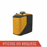
YellowScan Mapper UAV Lidar System

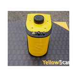
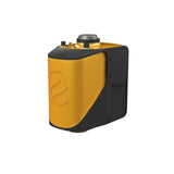
The new YellowScan Mapper is YellowScan's Livox-based UAV LiDAR system. The YellowScan Mapper UAV LiDAR system is equipped with a high-performance Livox Horizon laser scanner from Livox, a DJI-backed company. With a great point density, this LiDAR sensor allows our LiDAR system to fly easily at 70m AGL with a 120m swath.

We recommend a balanced 10 m/s flight speed to benefit from the Mapper’s point density while being productive. For example, flying at 70m AGL, 10 m/s, with 20% sidelap, you will be able to map 10 ha in 3 minutes.

The YellowScan Mapper is the right LiDAR tool to start with. Your data collection will be fast, accurate and cost-effective.

Discover our next-generation of integrated UAV LiDAR solution. With Livox technology, YellowScan sets new standards for UAV LiDAR mapping.

AGL Altitude

70m

System Precision

2cm

System Accuracy

3cm

Battery Weight excl.

1.5kg

Key differentiators

  • Best cost-performance ratio
  • High point density and advanced accuracy and precision
  • Low weight
  • Turn-key and simple to operate
  • Self-powered
  • Can be mounted quickly on any UAV, not only DJI

Technologies inside

  • Livox Horizon Laser Scanner
  • Applanix APX-15 UAV IMU
  • High-performance GNSS antenna

Integrations

  • Multirotor UAV
  • Helicopter UAV
  • Fixed-wing UAV

Watch the Mapper presentation

You‘ve got the power! A set of 2 worldwide certified batteries is shipped with the YellowScan Mapper+.

They are high-performance batteries that can easily be swapped in the field for increased productivity.

You have 3 different ways to power your YellowScan Mapper+. You can either use:

  • Skyport (on DJI M300 UAV) or Gremsy port
  • External Power source with the dedicated port (UAV’s power)
  • YellowScan Mapper+ LiDAR system’s own power

Just land, remove the first battery set and replace it by the new one. Take-off again! The YellowScan Mapper+ has 1h autonomy with its own battery.

YellowScan LiveStation

Don’t miss anything before going back to the office with Live Data transmission.

In-flight LiDAR Data transmission is enabled by a dedicated port. The YellowScan Mapper is compatible with the LiveStation, allowing live visualization of LiDAR data collection. Your mission can only be a success.

Mapper Backpack

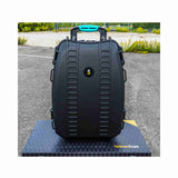
We decided to take advantage of this compact and lightweight LiDAR system and thought it would be good to have a backpack!

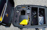
In this hardshell backpack with custom precut foam, you can easily carry your LiDAR with everything you need (LiDAR system, software, batteries, laptop, data storage). This backpack is the size of a carry-on luggage which fits in any airline overhead compartment.

Camera Module

You can now use our very own camera module on the YellowScan Mapper.

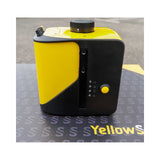
Operating the camera will be as simple as what philosophy indicates: “Just press the Yellow button”. The camera is powered through the Mapper and its data is stored on a dedicated SD card.

The Human-Machine Interface was thought out to be simple and efficient

With LEDs that indicate the LiDAR system’s status and its single button operation. As usual, we followed the “Just Press the Yellow Button” philosophy.

Data storage is not an issue.

You don’t need to connect to your LiDAR system to gather data. Just remove the USB stick from the system and go to your computer. As you receive two USBs, this helps you land and take-off again straight away thanks to the second USB stick.

Survey productivity matters to us! With one USB stick you can store LiDAR data from a 3 hour-survey.

.

No overheating LiDAR system!

We have optimized the temperature management with a double suction grid (air flow management) for a better aeration of the system. You can operate the Mapper+ between -20°C/-4°F and +40°C/140°F.

You said dual-sensor?

We designed a new unique internal port for RGB cameras. You will be able to connect other sensors, if needed.

Your worktool is reliable and protected! We designed a protective sliding piece to avoid any damage to the laser scanner glass during transportation.

No more scratches!
And if you forget to remove the protective sliding piece, The YellowScan Mapper will let you know, thanks to its detection system which will warn you before the mission starts.

IPW55 protection

The YellowScan Mapper has IPW55 protection meaning rain is not an issue during data collection: you have time to land. You can start your flight without rain in a weather that “might forecast rain”. If during the flight it starts raining, there is no issue flying back home.

Your LiDAR is safe. The LiDAR system is equipped with non-slip rubber pads. You can lay your system down without fearing to damage it.

High-quality GPS antenna

The GNSS antenna provided is able to receive superior signal from GPS L1/L2/L5/L-band, GLONASS G1/G2/G3, BDS B1/B2/B3, Galileo E5a/E5b/E6/E1. It has IP-67 protection from dust and water and a low wind-resistance design.

High-quality GPS antenna is a must to get high-quality georeferenced point cloud. You deserve it.


Add Ons

Warranty extention

LiveStation


Example of UAV integrations

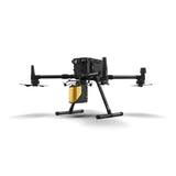
Connect your Mapper LiDAR system to your DJI Skyport.

The YellowScan Mapper can be used with the DJI Skyport. How could we miss this!

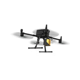
The Mapper is compatible with the DJI M300…but not only. We have a bunch of customers flying their UAV with our product: multirotor, fixed-wing and helicopter drones.

If you already have a M300 or M600, we have the dedicated mounting bracket to attach the Mapper LiDAR to your UAV.

Get a Quote

Please complete the form below to submit your quote request.