Cookies are important to the proper functioning of a site and we use them to help us offer you the best online experience. By using our website and/or clicking OK, you are agreeing to our use of cookies in accordance with our cookies policy. I Agree

DJI Phantom 4 RTK Drone and Accessories

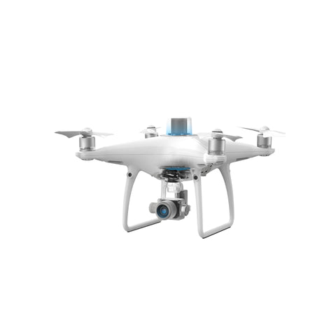
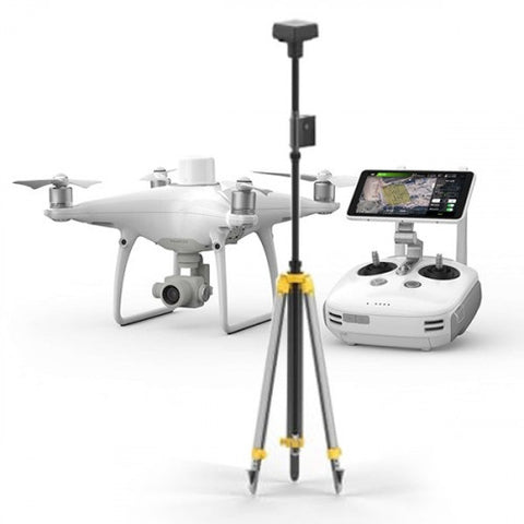
The DJI Phantom 4 RTK drone is DJI’s most compact and accurate drone mapping solution recommended for surveyors and geomatics professionals. The Phantom 4 RTK is a revolutionary drone in that it presents a new standard for drone accuracy offering centimeter-accurate data while requiring fewer ground control points. The Phantom 4 RTK is built for surveyors, offering a range of control schemes and complementary technologies, the DJI Phantom 4 RTK is developed to provide survey-grade results with greater efficiency than ever before. To complement the Phantom 4 RTK we offer precision photogrammetry software solutions from Datumate and DJI Terra.

Our drone specialists at GoUAV are available to advise you on your Phantom 4 RTK requirements and software solution to meet your needs. We help with specifications, demonstrations, quotations, pre-sales support, training, and repairs. For assistance with the Phantom 4 RTK solution, please get in touch with one of our sales professionals.


Buying a DJI Phantom 4 RTK Drone Solution?


Before you purchase your Phantom 4 RTK drone solution, you should familiarize yourself with the product features and the accessories that make up a complete solution for producing survey grade accurate results.


Table of Contents

DJI Phantom 4 RTK key features

DJI D-RTK 2 Mobile Station

Datumate photogrammetry software

DJI Terra software


DJI Phantom 4 RTK Key Features

The Phantom 4 RTK is purpose built for surveyors and offers significant features that allow this drone to produce the accuracy required by professional surveyors. It offers surveyors 1cm + 1ppm RTK horizontal positioning accuracy, 1.5cm + 1ppm RTK vertical position accuracy and 5cm absolute horizontal accuracy of photogrammetric models.

A new RTK module is integrated directly into the Phantom 4 RTK, providing real-time, centimeter-level positioning data for improved absolute accuracy on image metadata. Flight stability in signal poor regions is achieved with the addition of a redundant GNSS module.

The new TimeSync system was created to continually align the flight controller, camera and RTK module. Additionally, TimeSync ensures each photo uses the most accurate metadata and fixes the positioning data to the center of the CMOS sensor letting the image achieve centimeter-level positioning data. The Phantom 4 RTK controller features a built-in screen and is installed with the DJI GS RTK app, giving users a streamlined control scheme for surveying missions and other data acquisition scenarios.

The Phantom 4 RTK has the ability to connect with the D-RTK 2 Mobile Station, NTRIP (Network Transport of RTCM via Internet Protocol) using a 4G dongle or WiFi hotspot or store the satellite observation data to be used for Post Processed Kinematics (PPK)


DJI D-RTK 2 Mobile Station

The optional D-RTK 2 Mobile Station, a high-precision GNSS receiver that supports all major global satellite navigation systems, provides real-time differential corrections that generate centimeter-level positioning data for improved relative accuracy.


Datumate Photogrammetry Software

Datumate photogrammetry software produces exceptional accuracy compared with other photogrammetry software and is highly recommended for construction and surveying professionals to compliment the Phantom 4 RTK to provide the most accurate aerial survey solution. From automated drone mapping to high-precision outputs, Datumate’s photogrammetry software tools save costly field and office time, cut down operational expenses and achieve the most accurate results.

DJI Terra is an easy to use mapping software developed by DJI to help industry professionals transform real-world scenarios into digital assets. DJI Terra works seamlessly with the Phantom 4 RTK and allows for mission planning, data acquisition, area mapping and data analysis.

To order your Phantom 4 RTK surveying solution contact GoUAV now!

Get a Quote

Please complete the form below to submit your quote request.